Search
Log-in
Icy January
  • Icy January
  • A perfect storm
  • The triangle of darkness
  • Solidarity
  • Heroes
  • After the storm
  • References
  • All sites
  • News
  • Contact us
  • Power outages
  • Français
  • Skip to content
  • Skip to the footer's menu
  • All sites
  • News
  • Contact us
  • Power outages
  • Français
  • Log in
Hydro-Quebec
  • Icy January
  • Menu
  • log in
  • Icy January
  • A perfect stormActive page
  • The triangle of darkness
  • Solidarity
  • Heroes
  • After the storm
  • References
Pascal, meteorologist, Montréal, January 6, 1998, 2:00 p.m.

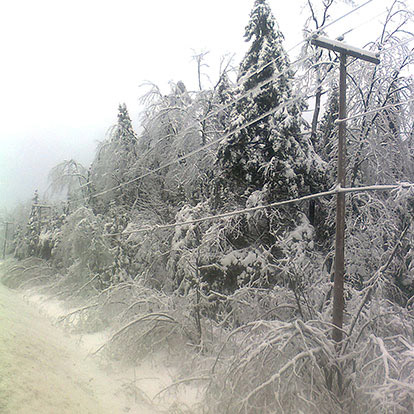
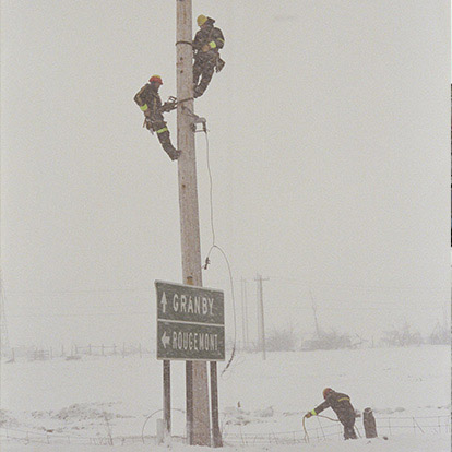
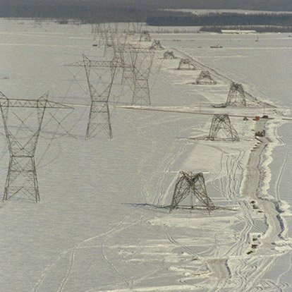
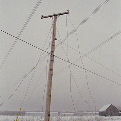
Extraordinary weather event

I have to see my boss in five minutes. I’ve got bad news. The first storm has deposited 10 to 20 mm of ice.

The situation wouldn’t be as critical if Mother Nature had left it at that. But all the analyses I’ve done of the most recent satellite images and weather models lead to the same conclusion: two more low-pressure systems are on their way to Québec. But I have no idea if they’ll bring ice pellets or freezing rain. What are we going to tell all the people shivering in the dark?

Son désactivé

When the ice storm of January 1998 struck, 78 mm of ice built up in southwestern Québec.

How freezing rain forms

Two conditions are essential for freezing rain. First, there has to be a low-lying layer of cold air with its temperature below the freezing point. And there has to be a large mass of warmer, humid air above it.

When those two conditions are met, ice crystals form in the upper clouds. Falling down through the warm air mass, the snowflakes melt and turn into raindrops.

As they continue downward, the raindrops hit the cold air mass and become supercooled. That means they stay liquid even below the freezing point. Then when they strike a cold surface, they freeze on contact.

Ice storms of the past

Freezing rain is hardly a rare occurrence in a Québec winter. In the Montréal area, between November and March, there are, on average, a dozen episodes of freezing rain. But some have been historic.

How freezing rain is measured

It’s hard to measure freezing rainfall, by its very nature. That’s because as the masses of air move, freezing rain can change into melting snow or ice pellets. Also, the amount of freezing rain that falls varies from place to place, depending on the relief of the landscape and time of day. Ice meters can measure the amount of ice on the ground, but not that on buildings or electrical towers. Casts and direct measurements on power lines are more accurate. That’s why the amounts of ice measured in the 1998 ice storm vary a lot from one municipality to another.

1998 ice storm

The 1998 ice storm was exceptional because of two unusual situations that occurred hundreds of kilometres away from southwestern Québec. First, El Niño caused a large mass of warm air to form over the Gulf of Mexico. Due to prevailing winds, this warm air mass moved to Québec and then another one formed. Second, the usual pattern of west-to-east prevailing winds stopped for a few days as a result of a major high-pressure system that stayed put over Newfoundland and Labrador.

The scope of the 1998 ice storm can therefore be explained by three successive freezing rainfalls over an area of 40,000 km2 within a very brief span of time. It was an unprecedented event that many have called a natural disaster, or act of God or nature.

Map of ice storm

According to Environment Canada, there were three episodes of freezing rain, and the average accumulation was between 50 mm and 70 mm. The regions of the Outaouais, Montérégie, Beauce and Montréal were the hardest hit.

  • January 5–6 (6:00 p.m.–8:00 a.m.)
  • January 7–8 (6:00 p.m.–8:00 a.m.)
  • Morning of January 8 to the morning of January 9

Triangle of darkness

The maximum freezing rainfall was recorded in Montérégie. A total of over 100 mm of freezing rain fell in the area between the towns of Saint-Hyacinthe, Granby and Saint-Jean-sur-Richelieu, dubbed the “triangle of darkness.”

Effects on transportation

The first observable effect of the ice storm was the difficulty getting around. Walkers slipped and fell, while cars were stuck in the ice or could only advance slowly, due to poor road conditions. Public transit moved at a crawl. People preferred to stay home, going out only when they had to.

Effects on vegetation

As freezing rain continued to fall, plants and trees were coated with ice, which many amateurs photographers found spectacularly beautiful. Some branches bent under the weight. Others broke, littering streets, yards, parks and woods. Many fell onto cars, and pedestrians were at risk of being hit.

Effects on transmission and distribution lines

Starting January 6, the ice storm struck the power transmission system in and around Montréal hard.

  • A short-circuit signal tripped switches that put transmission and distribution lines out of commission. Ground wires sagged under the weight of the ice so they touched live lines.
  • The suspension system of many transmission lines broke and fell, creating short circuits.
  • Fasteners holding power lines and ground wires snapped due under the heavy ice. Some towers were pulled down by the shift in load.
  • Towers collapsed, bringing others down after them in a domino effect. Only the sturdiest structures, such as angle towers, could stop the cascade of falling towers.
  • When the transmission lines were no longer working, Hydro-Québec used other circuits to provide service. But when they in turn collapsed, all hope of a quick solution died.

The collapse of the transmission system led to a breakdown in power supply. Although hydropower stations were still generating electricity, it could not get to the substations and the distribution system that would carry it to customers.

The ice storm also damaged the distribution system, which delivers power to customers.

  • In urban areas, fallen branches and trees damaged power lines and poles.
  • Many transformers caught fire.
  • In rural areas, power lines snapped under the weight of the ice and pulled down long lines of poles in a cascading effect. Violent winds also downed many distribution lines.

With the distribution system out of commission, customers had no power.

Other stories

  • Pascal Meteorologist

  • Joyce Reporter

  • Francine Emergency Response Advisor

  • Guy Line worker

  • Pierre Researcher

Important links

  • Link to main sections
    • Residential
    • Business
  • Link to some of our sites
    • About
    • Energy Wise
    • Security advice
    • Newsroom
    • Contact us
    • Power outages
    • Careers*
    • Our sites
  • Newsletters
  • Follow us
    • Facebook This link will redirect you to an external site.
    • Bluesky
    • X (Twitter) This link will redirect you to an external site.
    • LinkedIn This link will redirect you to an external site.
    • YouTube This link will redirect you to an external site.
    • Instagram This link will redirect you to an external site.
    • TikTok This link will redirect you to an external site.
  • Apps
    • Apple StoreThis link will redirect you to an external site.
    • Google StoreThis link will redirect you to an external site.
  • Site map
  • Terms and confidentiality
  • Manage cookies
  • Accessibility
  • Netiquette
  • Request for access and Privacy

© Hydro-Québec, 1996–2025. All rights reserved. * Website in French only | Who can consult this pageThis link will open a new window. This link will redirect you to an external site.