Important reminder
In the event of a flood, contact your municipality. They will advise the Ministère de la Sécurité publique du Québec, which coordinates all flood-related activities.
Mauricie
Every year, we work hard to limit the impacts of the spring runoff well before it begins
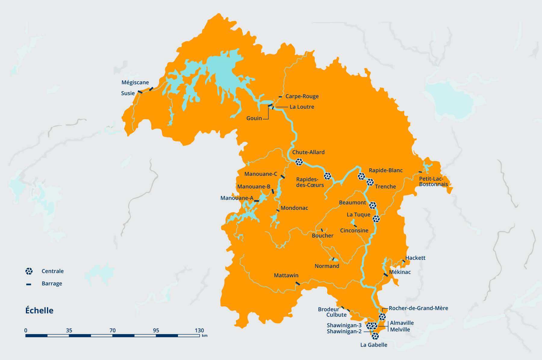
In the Mauricie region, Hydro-Québec is mainly present in the Rivière Saint-Maurice watershed, which includes Gouin reservoir and its main tributaries, the Manouane, Matawin and Mékinac rivers. To operate our facilities, which are set up in sequence along the river, we have to take many constraints into account. A decision made for the north will have an impact on areas further south and vice versa.
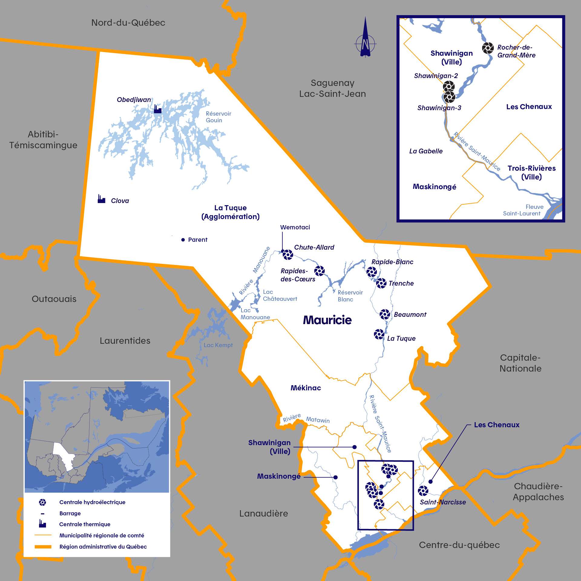
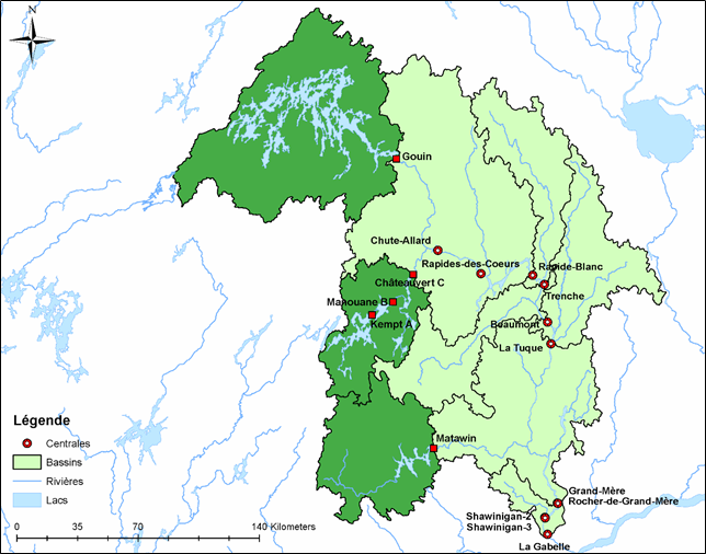
The Rivière Saint-Maurice watershed covers an area of 42,500 km2—about the size of Switzerland—and receives inflows from 100 tributaries and 36,000 lakes. In addition to Gouin reservoir, the watershed is home to several Hydro-Québec facilities with great reservoirs, including Matawin dam, Mékinac dam, and the three Manouane dams (A, B and C). These structures regulate 40% of the natural inflows in the Saint-Maurice watershed. The remaining 60% flow directly into the river without being held back.
Hydro-Québec’s presence in Mauricie:
- 10 generating stations in 9 locations
- 4 reservoirs created by the Gouin, Manouane, Matawin and Mékinac dams
- 1 buffer area consisting of Blanc reservoir
- 1 river stretching some 400 km, from the Gouin dam to the Fleuve Saint‑Laurent (St. Lawrence River)
- 1 watershed covering over 42,500 km2, or the size of Switzerland
A tool that identifies flows and water levels
We are installing measuring instruments on rivers and reservoirs where we operate dams and generating stations. They provide flow, water level and meteorological data. This data is available to you through a simple tool, which can provide information about flows on rivers and water levels in reservoirs.
Learn more about the Tool
Run-of-river generating stations do not have reservoirs and cannot retain the high flows of spring flooding
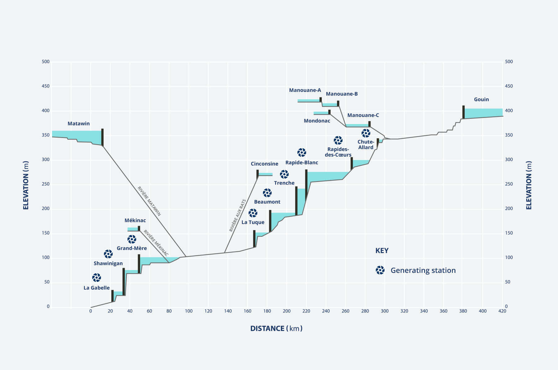
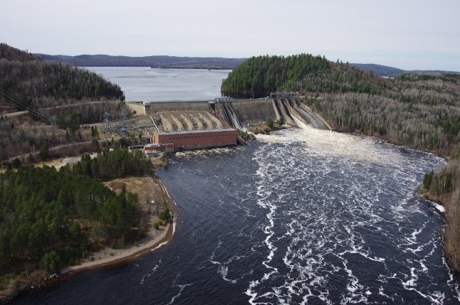
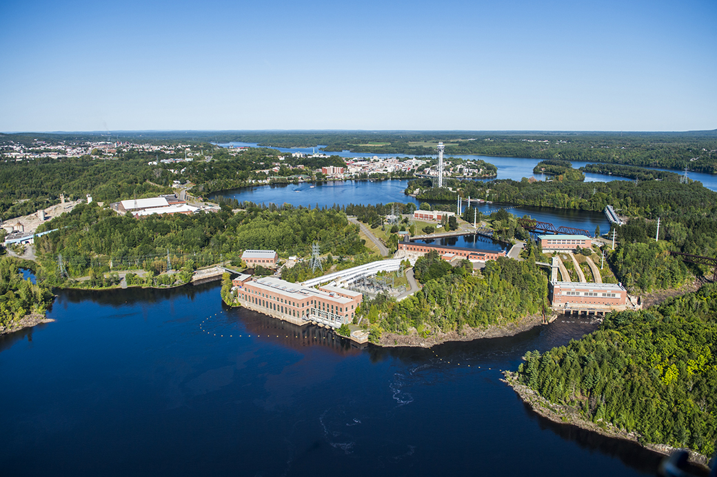
Our 10 hydroelectric facilities on the Saint-Maurice—Chute-Allard, Rapides-des-Cœurs, Rapide-Blanc, Trenche, Beaumont, La Tuque, Rocher-de-Grand-Mère, Shawinigan-2, Shawinigan-3 and La Gabelle—consist of run-of-river generating stations. These types of stations are supplied directly by the Rivière Saint-Maurice and have virtually no storage capacity, except for Rapide-Blanc. In the latter facility, the generating station has a small amount of storage that acts as a buffer between upstream and downstream during spring flooding or when we expect heavy summer rain that could cause flooding in the most sensitive downstream areas. However, the volume of this storage is limited, and it can only hold back water for a short period.
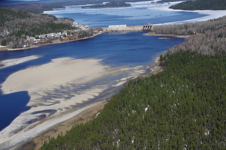
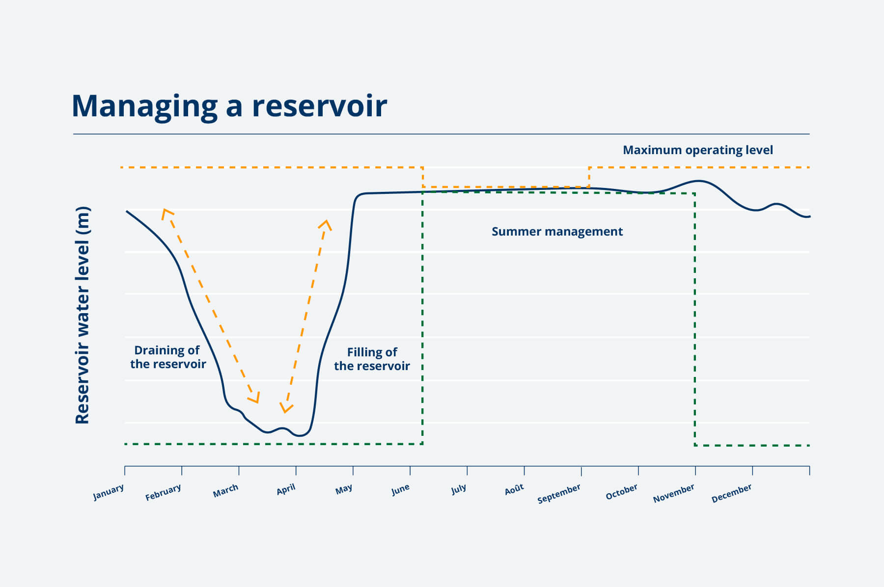
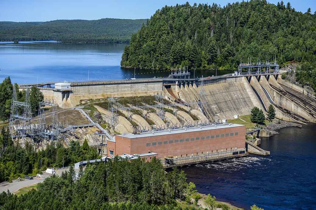
We store water in our reservoirs to reduce spring flooding
Every winter, Hydro-Québec draws down the level in its reservoirs in the Mauricie region to make room for spring runoff. Our reservoirs are then able to accommodate the water expected from snowmelt and rainfall. However, the duration, start date and extent of the drawdown varies from year to year depending on weather conditions.
During spring flood season, we manage the regulatable sub-watersheds judiciously to reduce the magnitude of the flood downstream. We proceed with caution, as some of our reservoirs can fill up very quickly, which can then lead to consequences downstream. The management of our facilities depends on the water levels expected. Our top priority is always public safety and the safety of our infrastructure.
Watch our expert explain how Hydro-Québec contributes to managing spring runoff along the Rivière Saint-Maurice.
We have access to various storage capacities:
- Multi-year reservoirs are very large reservoirs that regulate inflows over a period greater than one year. Their storage capacity is measured in weeks.
Gouin reservoir belongs to this category. Every spring, the gates of Gouin dam are the first to be closed by Hydro-Québec. At the peak of spring runoff, the flow discharged from the reservoir is as low as possible. Gouin reservoir acts as a headwater lake. One of its roles is to store excess water, which it will later release when the natural flow in the river becomes too low for the downstream generating stations to operate. For example, before Gouin dam was built, the flows in the Saint-Maurice varied between 170 m3/s during low-flow periods, and 5,700 m3/s during flood periods. Today, the flows are more evenly spread out throughout the year and are used to meet energy needs. - Annual reservoirs are emptied every year. Their storage capacity is limited to a few days, depending on water inflows.
In Mauricie, the reservoirs created by the Matawin, Mékinac and Manouane dams belong to this category. Aside from flood-management considerations, the operation of these reservoirs takes into account the effect of river levels and flows on riparian environments, as well as downstream water flow needs. These reservoirs also help reduce spring flooding. - The storage available upstream of a run-of-river generating station is very limited—a few hours at most—and cannot be used to reduce spring runoff. The forebay of Rocher-de-Grand-Mère generating station is a good example of this type of storage.
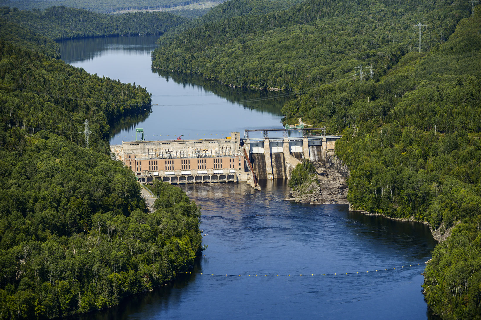
Gouin dam (May 4, 2017). The water that flows from upstream to downstream runs through the mini-turbines that supply electricity to the dam's auxiliary systems and to nearby customers.
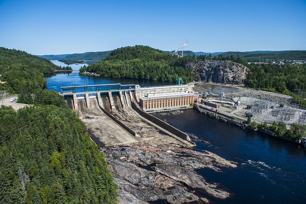
Trenche facility (May 4, 2017). The spillways discharge excess water inflows that cannot be fed to the turbines. Spillways ensure the safety of both the public and the facility; without them, the water would spill over the facility and threaten its stability.
Mékinac dam and its watershed: A sub-watershed in the Saint-Maurice region that requires special attention
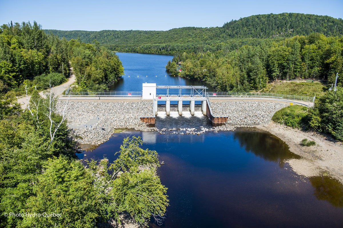
Mékinac dam is located at the southern tip of Mékinac reservoir/lake (Lac Mékinac), at the source of the Rivière Mékinac. Lac Mékinac is 16 km long and has a surface area of 23 km2, while its watershed covers 880 km2. All the natural inflows in this watershed supply the Rivière Mékinac downstream of the dam. Lac Mékinac has little storage capacity for the size of its watershed. It requires close monitoring and frequent adjustments due to the high variation in its water inflows from rain, storm cells and snowmelt.
Lac Mékinac is an annual reservoir; it is filled by the water in its watershed and emptied over a one-year cycle. The water level in the lake is maintained by the dam’s stoplogs. These stoplogs can be added or removed manually to increase or decrease the flow discharged, which in turn changes the reservoir’s water level. The water that flows over the stoplogs spills into the Rivière Mékinac, where it helps sustain aquatic plants and wildlife.
The operating range of Lac Mékinac depends on the design criteria of the dam, which determine the maximum threshold that needs to be respected to ensure the safety of the dam and the public. The management of Mékinac dam is based on the anticipated water inflows. For example, if significant rainfall is expected in the coming days and the reservoir is already quite full, Hydro-Québec will need to release some of the stored water to accommodate the expected inflows. The safety of the public and our facilities is one of our core concerns and guides our every decision.
To learn more about the Saint-Maurice watershed, visit the website of the Bassin versant Saint-Maurice organization (site in French only).
Diaporama
Le contenu qui suit est un diaporama d’images sur : Les normes


-
Bassin St-Maurice -
Shawinigan Complexe -
La Trenche Generating station -
La Tuque Generating station
Frequently asked questions
Could we find out what the flow of the Rivière Saint-Maurice and the level of the reservoirs in the Mauricie region are in real time, so that we can protect our property (docks, land, homes, cottages, etc.)?
When there is a potential for flooding, Hydro-Québec is in continuous contact with the Organisation régionale de la sécurité civile (ORSC), and we give them daily updates of the river’s flows. Since the 2017 spring flood, during the period when water inflows are closely monitored, the ORSC holds daily conferences for the municipalities who are tracking the situation. At these meetings, Hydro-Québec shares details about expected water inflows and answers questions.
Why is it that, during some flood periods, Blanc reservoir is not full while the areas downstream of it are flooded?
The Rapide-Blanc development has a small amount of upstream storage (sometimes known as pondage) that acts as a buffer between upstream and downstream when heavy rain is expected and the flood risk is high for the most at-risk downstream areas. However, the volume of this storage is limited and it can only hold back water for a short period. It should also be noted that the entire watershed covers an area of 42,651 km2 and the Saint-Maurice is 381-km long. Very often, in spring, while there may not be much snow left in the Rapide-Blanc area, there is still a thick layer of snow covering the ground in the north. In general, if the spring thaw starts late and there is still a lot of snow left in the north of Mauricie in mid-May, Blanc reservoir will fill up later than it does during an average spring.
Can Hydro-Québec ensure an optimal level at Blanc reservoir for the start of fishing season?
Blanc reservoir can only be used for a limited time during the spring thaw. Hydro-Québec manages the river with caution and diligence to reduce the impact of the spring runoff as much as possible on all neighboring communities and infrastructure, both upstream and downstream of the reservoir. In addition to the risk management involved in these efforts, we also take into account the various—and sometimes conflicting—expectations of the different communities and areas affected.
Can Hydro-Québec lower the level of the forebay at La Tuque generating station during flood periods to prevent water from backing up in the Rivière Croche?
La Tuque generating station is a run-of-river station, which means that it is powered directly by the river’s flow and has virtually no water storage capacity. The operation of this type of facility must therefore take into account rain, temperature and snowmelt conditions. Hydro-Québec manages the spring runoff to reduce its impact on all residents, without favoring any particular group. If we didn’t, the situation would be much worse every year. Residents living immediately downstream of our structures are in stretches of the river whose water level cannot be regulated during flood periods. They are therefore more vulnerable to the vagaries of the weather than the residents living around the bays upstream of the facility.
Why is it that, in 2017, the shorelines in the Grandes-Piles area were dried up, whereas downstream of Grand-Mère some of the properties were flooded?
The water storage capacity upstream of Rocher-de-Grand-Mère generating station is quite low (nearly 300 times lower than the capacity of Gouin reservoir). As a run-of-river facility, Rocher-de-Grand-Mère cannot hold back the spring flood in any significant way. The level of the upstream forebay is kept low to reduce the impact of the flood on this section of the river. If the upstream level were higher during the spring flood, it would increase the risk of impacts on the upstream section of the river, without reducing the floods downstream.
Why is Hydro-Québec slow to open the gates of the Shawinigan dams during flood season?
The two generating stations that are part of the Shawinigan complex are run-of-river stations, which means that they do not have a reservoir to hold back water. Hydro-Québec opens the gates of the Shawinigan dams when the quantity of water in transit is higher than the generating capacity of the two stations combined. Mother Nature determines when this quantity is reached.
Questions on how Hydro‑Québec facilities are managed? Write to us at Affairesregionales@hydroquebec.com.